Releases: albar965/littlenavmap
Version 2.2.4
Edit 10 March 2018: Added German manual translation LittleNavmap-manual-language-package-de-2.2.zip.
► User manuals for Little Navmap and Little Navconnect in all formats and languages.
Notes
This release contains small bugfixes, new keyboard shortcuts, enabled IVAO online network, AviTab export and more flight plan export formats.
Changes from Release 2.2.3 to 2.2.4
Flight Plan Export
- Added saving and loading of FlightGear XML flight plans (
.fgfp) also covering SID and STAR. #361 - MDX flight plan export for Leonardo Maddog X added. #232
- Added RTE flight plan export for QualityWings aircraft. #335
- Export for AivlaSoft EFB (
.efbrversion 1 - currently no SID and STAR). #226 - Added saving of PNG or JPG map images for AviTab to file menu. Includes JSON calibration file. #310
- Added flight plan export for online networks including dialog for additional data. #317 (vPilot,
VFP) and #176 (IVAP and X-IVAP,FPL) - Added FPL flight plan export for FeelThere aircraft. #206
- New flight plan export for Level-D (
.rte). #206 - Adapted flight plan file type detection to new formats and improved it for drag and drop loading. Files are now accepted for dropping/loading independent of file extension.
- Now automatically suggesting a numbered filename if file already exists when exporting or using
Save as. Same for aircraft performance files. - Reorganized export flight plan menu items into categories (Aircraft, Online, etc.) for better overview.
- Changed default export folder for aircraft flight plan formats to use simulator base folder instead of
Documents.
Online Networks
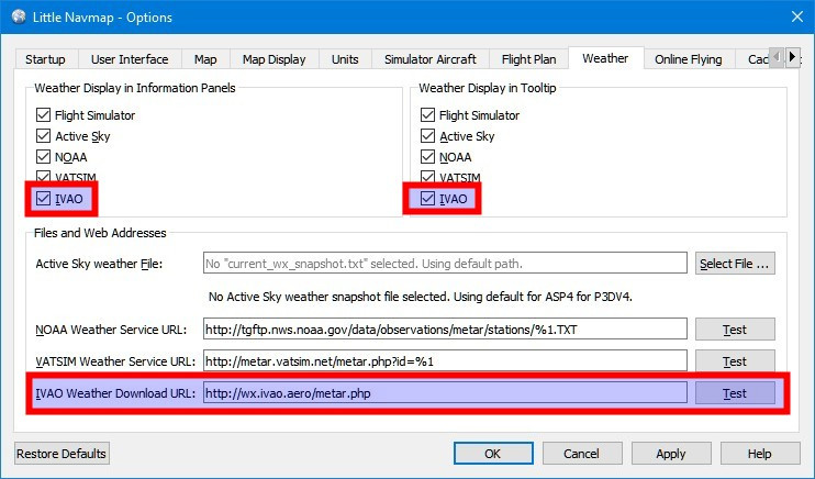
- Enabled IVAO online network support based on mirror on www.littlenavmap.org. #244
- Now displaying flight simulator type in information window for online network clients.
Help
- Changed default email, manual and help link URLs from Gitbook to www.littlenavmap.org. #238\
Manuals in all formats and languages can be found here: Little Navmap and Little Navconnect Manuals. - Moved help URLs into configuration file
urls.cfgwhich can be overloaded in settings directory. #238
Map
- Fixed issue where MORA data was displayed only with Navigraph data enabled. Now always shown independent of selection. #331
- Changed taxiway color for better visibility with light backgrounds.
- Added taxiway colors and pens to
little_navmap_mapstyle.inito allow configuration. - Logbook userpoint icon now displayed using an offset from airport icon to avoid covering the airport symbol. Hotspot of logbook userpoint is now top left of the symbol. #366
- Changed AI/multiplayer aircraft on ground to appear earlier when zooming in.
- Now disabling text in MORA display if it gets too small to avoid garbled up display.
- Now hiding the scalebar when saving map images. Scale bar is now only included when printing.
- Fixed several display issues with procedure legs.
Flight Plan and Performance
- Fixed issue where selecting a parking position as departure resulted in zero cruising altitude in flight plan (FSX/P3D
.pln). - Now disabling aircraft performance collection when sim is paused or replaying (replay only detected on X-Plane).
- Relaxed maximum distance requirements for waypoints in route string parser.\
Airports are now always used independent of distance to previous waypoint. This allows to build plans likeEDDF KORD EDDM.\
#376 - Fixed display and conversion issues in aircraft performance when using metric units.
- Vertical descent speed, descent speed and descent rule of thumb now displayed correctly.
- Fixed route description parser to ignore runway designations attached to airport like
USSS/08R ... ZMUB1200/33. - Route description parser can now read long SID and STAR names like
ENVA UTUNA1Avs.ENVA UTUN1A.
Scenery Library
- Airports with open helipads and closed runways are now considered open.
- Now considering helipads for rating calculation for airports.
- Fixed issue with error messages when loading OpenAIR files with missing airspace class. Now omitting only the invalid airspaces instead of the whole file.
- Now looking for registry keys in a case insensitive manner to avoid problems where FSX or P3D could not be found.
User Interface
- Added function key shortcuts in menu
Window->Shortcutsto have quick access to search, flight plan, map and more. #364 - Added shortcuts to switch between styles
Fusion(Shift+F2) andNight(Shift+F3). - Added links to airport folder
Documents/Little Navmap Files/ICAOfor airport information. Links to all files in the related folder are shown if the path exists for an airport with the given ICAO ident. The path is locale sensitive, e.g. in GermanDokumente/Little Navmap Dateien/ICAO. This depends on completeness of the translation. Try both variants (Filesvs. your system language) if in doubt. Clicking on a link opens the file in the default editor or viewer of the system. - Fixed wrong test in options dialog for online
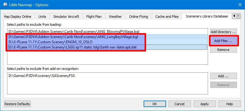
status.txtfile. Now looking for the correct values to verify the file or download. - Default folder is now the simulator base path when selecting exclusions in the options dialog on tab
Scenery Library Database. - Fixed issue where date display used 12 hour time without AM/PM indicator. Now always using 24 hour time for UTC time display.
- Moved all context menus a few pixels off the cursor to avoid accidental selection of first entry on touchpads or some mice.
- Changed lengthy prefix for custom map themes to
*in the drop down box on the toolbar. - Limited text length for files and paths in scenery loading dialog to avoid growing the progress dialog too large.
- Shortcuts (menu
Window->Shortcuts) are now enabled on all windows.
Weather
- Fixed default NOAA and VATSIM weather URLs to use HTTPS/SSL.
- Added migration code to convert NOAA weather URL to use SSL/HTTPS if user left URL unchanged.
- Made METAR parser more tolerant for invalid temperature values not separated by a
/. - Fixed issues with missing weather updates when switching airport weather.
Configuration
- Now reading environment variable
LNM_RENDERERfor potential fixes on crashes or graphic problems.\
To use desktop OpenGL renderer set it todesktop. \
Use Angle to DirectX adapter for rendering:angle.\
To use the software renderer set it tosoftware. - Added
[Options]/PixmapCacheallowing to change pixmap cache size as a potential fix for disappearing icons. - Added preliminary options for manual application of user interface font configuration in settings. #373. Example:\
[Options]\
GuiFontFamily=FONTNAME\
GuiFontFile=FILE.ttf(Optional)\
GuiFontPixelSize=12(Optional) [Options]/Languageoverride in settings file now fixed for online help and legend loading.
related from Little Xpconnect version 1.0.14
- Fixed issue with AI detection where aircraft remained on map moving along with the user aircraft after deleting AI in simulator.
- Now linking Xpconnect statically to Qt to avoid plugin conflicts with libaries in Linux.
See the included CHANGELOG.txt or here online for a complete list across all versions.
All files are checked by VirusTotal.
Version 2.2.3
- Fixed crash when reading unexpected value in "activeflightplanwx.txt" of Active Sky.
- Fixed crash when doing "Show all" after "Select all" in search result table while using a spatial query.
- Problem solved where altitude restrictions in procedures caused an invalid "cannot comply to altitude restrictions" error.
- Fixed several display issues in profile (e.g. LPPR ADNOV I17 at CI17).
- Fixed drawing issues with overlapping procedure leg points having different altitude restrictions (e.g. LPPR ADNOV I17 at CI17).
- Fixed issue where flight plan airports or navaids were not detected when airport display is off.
- Elevation profile showed wrong values for altitude on rightmost position in some cases.
- X-Plane scenery_packs.ini now read case insensitive to avoid errors.
- Little Xpconnect: Acf file of user aircraft is now read for more attributes like e.g. identifying helicopters.
- X-Plane scenery_packs.ini now read case insensitive.
- Disabled display of flight plan position in information window since it needs too many updates to function correctly.
- Full French and Spanish translated PDF manual included and online help is now complete.
- Updated French legend.
Version 2.2.2
Update
- Added French translation package for the manual (
LittleNavmap-manual-language-package-fr-2.2.zip). Install this to get access to the French legend and online help (Manuel Utilisateur de Little Navmap). Includes the PDF manual. Thanks to Patrick JUNG alias PATBEST for translating the manual!
Note: Updated LittleNavmap-manual-language-package-fr-2.2.zip on Sunday, 16 Dec 11:40 UTC.
Changes from Release 2.0.3 to 2.2.2
For more details on fixed issues look at the included CHANGELOG.txt or here online for a complete list across all versions.
Click on images for large view.
Quick Overview
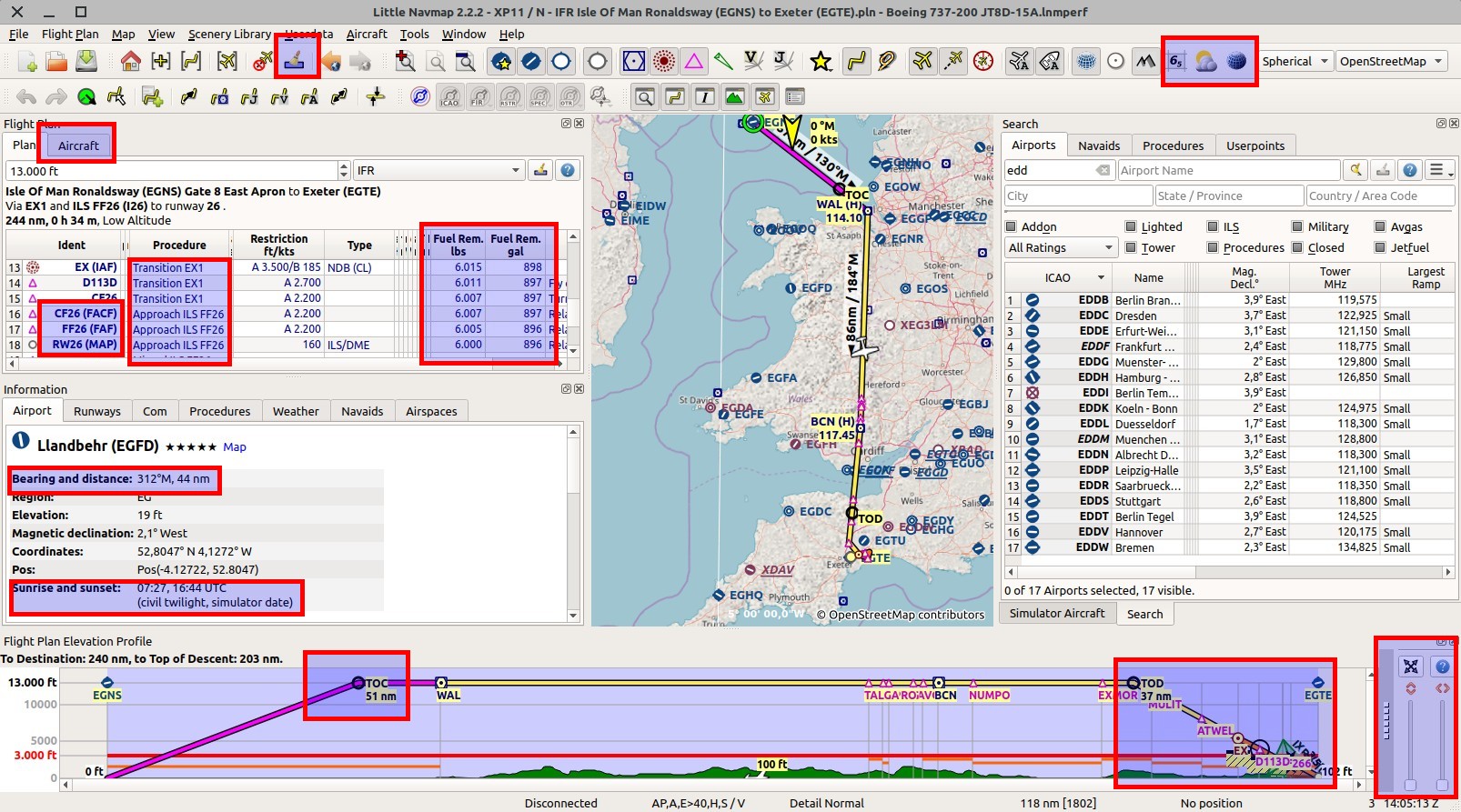
- Aircraft performance, fuel planning and more.
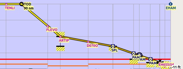
- Elevation profile now zoomable, displays top of climb and procedure altitude restrictions.
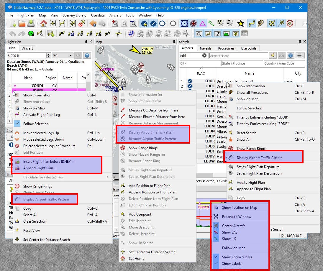
- Display of Airport traffic pattern.
- MORA Grid (minimum off-route altitude grid) shown on map.
- Sun shadow on map.
- Airport weather symbols on the map.
- Modifier mouse clicks in map. E.g.
Ctrl+Clickto start measurement orShift+Clickto place range rings. - Sunrise and sunset for airport in information.
- Bearing and distance to user aircraft in information display for airports and navaids.
- Better printing for map and flight plan.
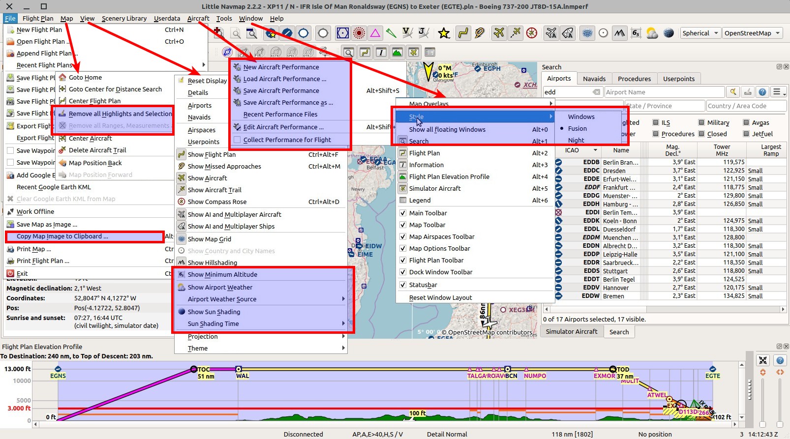
- Insert flight plan at any position into the current one.
- Change style (also
Night) on the fly without restart from the menuWindow. - Copy map image to clipboard.
- Performance issues with X-Plane airports fixed.
- Prepared for Active Sky XP.
New online manual chapters and/or changes
- Major update and enhancements in elevation profile: Profile and Legend.
- Aircraft performance:General,Editing and New Flight Plan Table Columns.
- Airport Weather: General, Menu Items and Legend.
- Sun shading.
- New settings, crab angle and next wayppoint: Compass Rose and Legend.
- Airport traffic pattern: General, New Menu Items and Legend.
- MORA Grid (minimum off-route altitude grid): New Menu Item and Legend.
- Mouse clicks with modifiers in map.
- Switch user interface styles on the fly.
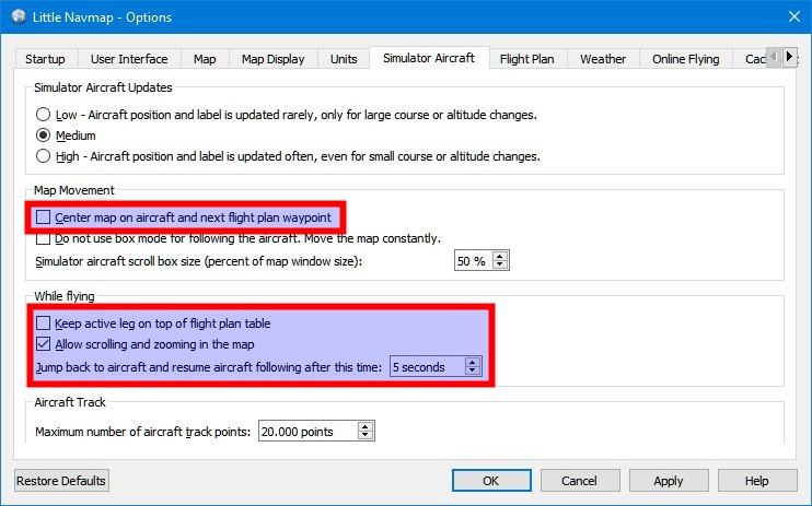
- Options for map display and simulator aircraft: Avoid blurry map and more details for scrolling and zooming while flying.
- X-Plane scenery_packs.ini is used now.
- Scenery loading can now exclude files.
- Improvements to printing.
- New airport related menu items in procedure search.
- Insert flight plan into current plan.
- Sunrise and sunset for airport in information.
- Bearing and distance of user aircraft to airport or navaid in information.
- Show more less data in aircraft progress.
- Better highlighting for airspaces from information window.
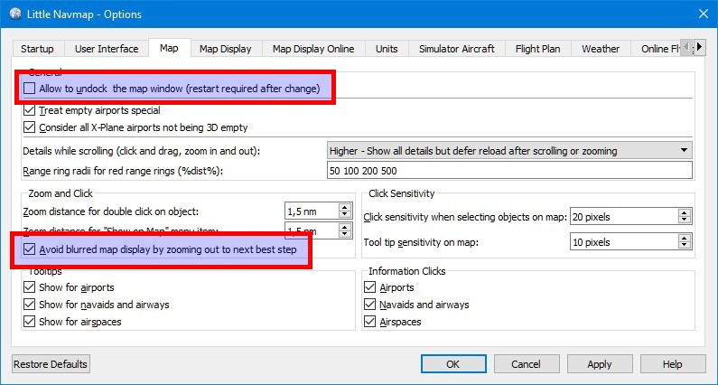
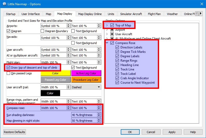
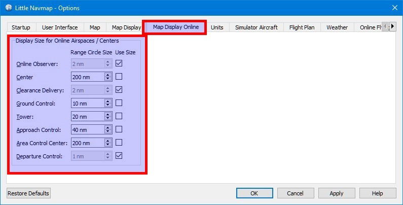
New Options
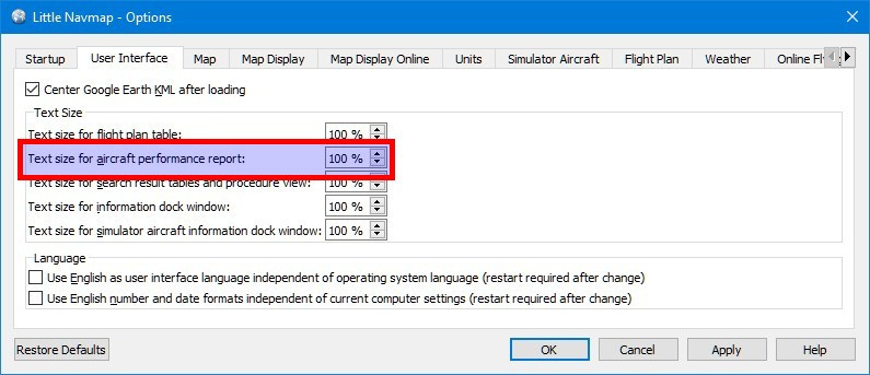
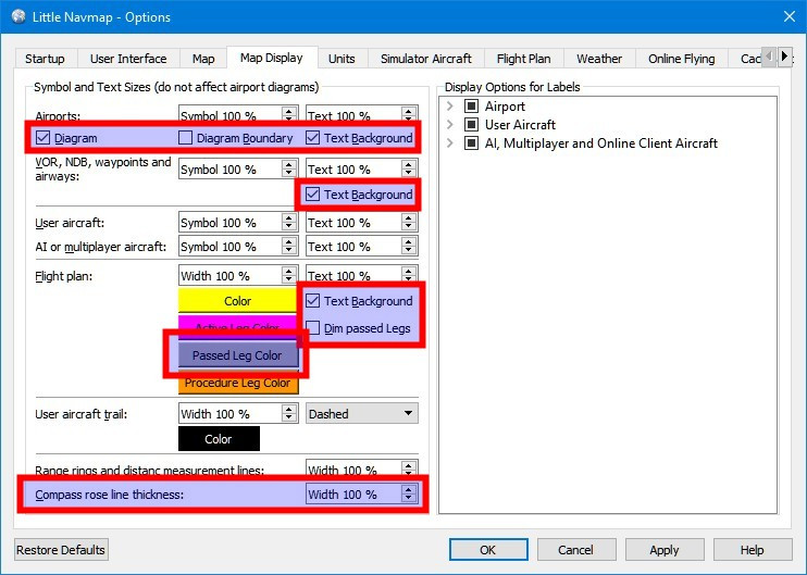
Tooltips in dialog Options give more help.
Note that some options were moved around in the options dialog. These are also marked in the images.
Map
Map Display
Map Display Online
Flight Plan

Scenery Library
User Interface
New Features
Elevation Profile
- Added scrolling and zooming ability to elevation profile. Elevation profile now has a context menu also including
Show on Mapand more functions.
Added splitter to elevation profile dock window which has sliders for zooming vertically and horizontally. These can be hidden by dragging the splitter to the right.
Zooming can also be done using mouse wheel (Wheel+Shiftfor vertical zooming).
Added keyboard navigation using cursor keys and numpad keys for zooming and scrolling.
Panning in elevation profile with mouse click and moving like in map. Double click zooms to position on map. #34 - Elevation profile now uses same aircraft icon as map. Changed elevation profile to completely adhere to map painting settings like line width, text size and symbol size. Profile display now hides flight plan if hidden on map. #298
- Adjusted elevation profile to display passed, active, straight-in and circle-to-land flight plan legs in the same colors like the flight plan on the map. Navaid symbols are now shown on the descending or ascending line. #298
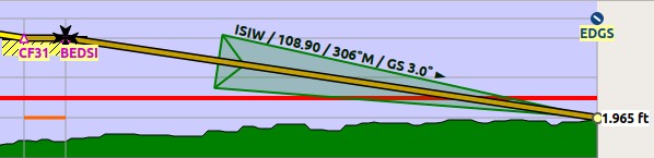
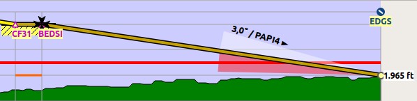
- Added option to display ILS and VASI slopes in elevation profile if an approach is selected. Menu items allow ...
Version 2.0.3
This release contains mostly bugfixes.
Changes from Release 2.0.2 to 2.0.3
Online Networks
- Fixed issue where simulator, AI or multiplayer aircraft did not move or were not updated on the map with certain settings.
- Now showing both online client and simulator aircraft tabs if user clicks on own aircraft when using online network.
- Both online and simulator information is now shown when clicking on shadow AI/multiuser/simulator aircraft.
- Fixed issue where online ATC was not removed from the map when the related center shut down.
- Online network ACC and FIR regions now have a default radius of 100.
- Removed error dialog for online network downloads. Now showing online network errors/status in statusbar on the connection status label and tooltip.
- Fixed issue when parsing whazzup with small timeintervals. (atools)
- Now assuming that aircraft is on ground for VATSIM and GS smaller than 30 kts (VATSIM has no on ground indication). (atools)
- Fixed wrong tooltip for online shadow aircraft which appear both in simulator and online network. Now showing tooltip for simulator aircraft.
User Interface
- Rearranged controls in search window to allow smaller dock windows.
- Now showing warning message box if SSL/HTTPS was not initialized due to missing MSVC redist installation or other issues.
- Increased size of status bar field for time to avoid creeping/flickering field in macOS.
Flight Plan
- Fixed several issues with copy CSV to clipboard from flight plan and search result tables.
- Fixed issue where route type (High/Low Alt) was assigned wrongly after flight plan calculation or loading flight plan.
- Fixes for flight factor flight plan export to corte.in. RNAV approaches should be recognized now.
- Flight plan names for flight factor flight plan export to corte.in are now made unique when saving.
- Fixed issues with export for flight plans for iFly 737 that could crash the simulator. (atools)
- Fixed issue where translated parking names were used in PLN files which resulted in wrong flight plan departure in saved file. This can appear in the French and Spanish translation. #243
Map
- Added departure and destination to map label for online network and AI aircraft.
- Disabled SSL for OpenMapSurfer theme due to problems on macOS.
- Now hiding all airspaces at small zoom distance when airport diagram is shown.
- Fixed issue where airspace was not displayed when selecting "show information".
- Now ignoring null frequencies on airspaces.
- Fixed issues with map context menu where "Show ..." and "Show ... in search" used the wrong map objects, i.e. "Show Network Client" showed airport in information window.
- Now using consistent priority where online and simulator aircraft are now prioritized above airports when clicking in the map for all show functions.
Misc
- Fixed issue where program cannot be opened by Linux file managers.
- Fixed translation issues in navserver resulting in confusing messages in Little Navconnect log window. (atools)
- Now showing coordinates in userpoint search result table.
A "Reset View" from the context menu is required to show the new columns. - Increased Garmin userdata export ident length. (atools)
- Fixed issue where aprons from stock airports remained in add-ons when loading FSX or P3D scenery.
- Fixed missing first update of X-Plane weather when starting X-Plane after Little Navmap.
- Now disabling less used search options on first startup after initial installation to get a less cluttered user interface.
- Added option to disable less used type filters in nav search.
- Workaround for partially invalid NDB and waypoint structures in APX27190.bgl from P3D v4.3 which causes errors
when reading the scenery library.
Version 2.0.2
Notes
- It is recommended to reload the scenery library.
- X-Plane users: Reinstall the included Little Xpconnect 1.0.9 for bug fixes regarding magnetic variation.
- Translations for the graphical user interface are included with the download.
Translation packages are not required.
Changes from Release 1.8.5 to 2.0.2
Quick Overview
- Several user interface translations included.
- Support for online networks like VATSIM or custom networks.
- User defined waypoints: Complete management, import, export, search and display.
- More flight plan export formats.
- Added menu options to save waypoints instead of SID/STAR or approaches.
- New airport display options.
- Compass Rose
- IVAO weather and nearest NOAA weather.
- Included Navigraph AIRAC database was updated to cycle 1801.
New online manual chapters and/or changes
- Userpoints
- Userdata menu
- Userpoint map context menu items
- Online Networks
- Compass Rose
- Edit flight plan positions
- Coordinate formats
- Customize display radius for online centers
- Customize userpoint icons
New Options
Click on image for large view. Tooltips in dialog Options give more help.

Translations
- Github Issue: #135
- Program user interface translations: Dutch, Brazilian Portuguese, French, Spanish and German. All complete.
No language packages needed. Thanks to all who contributed! - Included map legend in Spanish, French and German.
- Help system now more flexible and can load legend and help files if present for language.
Also uses a fuzzy way to find files by ignoring language region/country
likept(Portuguese) vs.pt_BR(Brazilian Portuguese). - French offline PDF manual is from previous version. Full translation will be provided as an update package.
Thanks to Daniel "Wolf", Eddy Crequie, merspieler, Patrick JUNG , Ricardo Vitor and Stephan Leukert for the translations.
Online Networks
- Github Issue: #45
- Manual: Online Networks
- Added IVAO, VATSIM and custom online networks. IVAO is currently disabled due to missing clearance.
Need volunteers to run a mirror. - All online network tabs and menu items are hidden in Little Navmap until online is activated in
dialogOptionson tabOnline Flying. - Update rate and URL configuration for custom networks in dialog
Optionson tabOnline Flying. - Display of clients, servers and online centers on map, in information windows, search tabs and context menus.
- Search highlights and tooltips for centers and client aircraft similar to airports and navaids.
- CSV export via clipboard for all online information in search window.
Userpoints
User defined waypoints like visual reporting points, bookmarks, points of interest and others.
- Github Issue: #3
- Manual: Userpoints
- New main menu
Userdatawhich provides various import and export options and more. - A new search tab
Userpointsin theSearch Windowfor editing and searching with the same functionality
as the other search tabs. - New menu entries in map context menu to add, edit, delete or move userpoints.
- Information window and map tooltips can display userpoint information on tab
Navaids. - Edit dialog for userpoints also allows bulk edits on more than one selected point.
- Add userpoint dialog remembers input to ease adding more than one similar point.
Content can be cleared using the reset button. - Add dialog is context sensitive and prefills airport data if you add a bookmark on an airport for example.
- Add userpoint from map is filled with actual elevation at clicked position (only for GLOBE data).
- Coordinates can be edited manually in edit/add dialog. More than 10 coordinate formats are recognized. See tooltip on
Latitude and Longitudefield. - Userpoints can be added to a flight plan and are converted to flight plan user defined waypoints (green square).
- A timestamp of last change is kept for each userpoint which allows to find latest changes or imports.
- Userpoints can be temporary. These will be removed on startup.
- Flight plan drag and drop editing allows to add userpoints.
- Import and export for CSV (format from other well known programs), Garmin
user.wptand X-Planeuser_fix.dat. - Export to a XML file suitable for the FSX/P3D BGL compiler.
- Icons and types can be extended by placing SVG files with names like
userdata_My own Userpoint Type.svgin
the settings directory. Icons for stock types can be changed by placing an icon with the same name like
userdata_Airstrip.svgin the settings directory. See customization below. - Option for automatic creation of userpoint entry of type
Logbookfor each takeoff and landing.
Logbook entry for landing contains trip information like average speed, fuel consumption and more. - Made naming in GUI more consistent.
Userpointsare bookmarks, VRPs, etc.,
Positionsare user defined positions in a flight plan. - Creating backups of file
little_navmap_userdata.sqliteon startup since undo/redo is not available yet.
Flight Plan Save and Export
- Added menu options to save waypoints instead of SID/STAR or approaches. This affects all flight plan formats.
Note that procedure information is omitted in the flight plans if enabled and cannot be reloaded.
#195
See Save Waypoints for Approaches and Save Waypoints for SID and STAR
in the manual. - New flight plan export formats: Blackbox Simulations Airbus, iFly 737, ProSim, UFMC and X-FMC.
- Added
Show in SkyVectorto export menu. - Can now load FSC flight plan files. Does not load procedures.
- Save button is now always enabled to allow saving PLN file again after P3D changes file on loading.
- Added option to save FSX/P3D flight plans using short names.
Optionson tabFlight Plan. - Export clean PLN flight plan file now remembers its own directory to allow saving to separate folder.
- Fixed issues where circle-to-land procedures were not loaded properly and were incorrectly assigned to a runway.
- Fixed issue where STAR procedures with runway assignment were not loaded correctly.
- Fixed issues in
corte.inexport for flight factor aircraft. LastDCTis now omitted on export and full names
are used for approach ident (I16Lbefore, nowILS16L). - Fixed issue where flight plan was saved in the wrong format after undo/redo and
Save as. This resulted in e.g. FSX PLN content in a FMS file. - Fixed issue when loading Fsbuild created flight plans which are missing the altitude field.
Flight Plan
- Coordinates of flight plan user defined waypoints can now be changed in edit dialog.
See Edit Flight Plan Position. - Now highlighting flight plan segments traveling wrongly against one-way airways in red to indicate error.
- Showing ILS frequency in flight plan table if an ILS or LOC approach procedure is used.
- Added follow selection mode to context menus of the flight plan window.
This will center selected navaids or airports on the map using the current zoomlevel when
enabled. #129 - Added
zoom to departureoption in parking question dialog which shows up before saving. This allows to quickly
assign a parking position on the map. - Fixed display issues around procedure names and suffixes.
- Now showing navaid ranges for navaids which are parts of procedures E.g.
Show navaid rangefor a
NDB which is part of a procedure.
Flight Plan Description
- Fixed errors in flight plan descriptio...
Version 1.8.5
Notes
Please reload the scenery database to fix problems with incomplete airways.
Edit Feb. 7 2018: Added German and Dutch Translation packages
German translation by merspieler, Stephan Leukert und Alexander Barthel.
Dutch translation by Eddy Crequie.
See here for more information about translation packages.
Changes from Release 1.8.4 to 1.8.5
- Fixed errors when compiling the X-Plane CIFP files that appear since AIRAC 1801.
- Updated included Navigraph database correcting airways.
- Fixes for missing airway segments in scenery library compiler for all formats (FSX, P3D, X-Plane and DFD). #201
Version 1.8.4
>> Please reload the scenery databases to avoid problems with saved flight plans. <<
- Added flight plan export for Reality XP GTN and GNS units.
- Added option to save Garmin flight plans with user defined waypoints only to avoid locked waypoints on AIRAC cycle mismatch.
- Added search for X-Plane 3D airport flag in rating dropdown list. Needs scenery database reload.
- Added display for new airport region where available. Needs scenery database reload.
- Now displaying runway names for SIDs and STARs with reference to multiple parallel or all runways in procedure search. Partial solution for #179. Needs scenery database reload.
- Changed route description text field to monospaced font and changed wrapping for word to any for better readability.
- Added options to disable tooltips for selected map features: airports, navaids or airspaces.
- Helipads can now be selected as a start position on the map.
- Now using correct AIRAC cycle from nav database when writing FMS files. Used simulator version previously which could result in X-Plane warnings. Needs scenery database reload
- Added warning dialog when AIRAC cycle is not available when saving flight plans in X-Plane FMS 11 format.
- Departure runway is now correctly assigned according to SID runway when loading from formats which do not support departure parking (e.g. FMS or FPL).
- Fixed issues where X-Plane cannot load STAR in FMS 11 flight plans because runway reference is missing.
- Fixed issue where helipad name was not loaded correctly from FSX PLN files in certain cases.
- Fixed Linux build to avoid problems with shared libraries on some platforms.
- Removed unneeded startup script for Linux. Program executable can now be started directly from any directory without setting library path.
- macOS compatibility changed since program does not work on 10.9 and below due to Qt requirements. Now at least version 10.10 is required. Now showing error dialog if macOS is too old. Program now refuses to run on Mavericks or older.
- Fixed warning dialog for Linux and macOS which should show up only on Windows first startup.
- Made program more tolerant for older database files.
- Small adjustment to taxiway labels to show more often.
- Updated translation files, French manual and legend.
from atools version 2.8.4
- Fixed problem where translations for second and third languages were loaded for some regions.
- Solved problem where translation files were loaded mixed in some cases.
- Logging library paths now for debugging.
- Added Garmin GNS XML flight plan export.
- Added option to save GNS XML flightplans with user defined waypoints.
- Column "arinc_name" in table "approaches" is now filled for SID and STAR to get runway
information for multiple or all. Needed for future fixes of #179. Needs scenery database reload - Added new columns "region" and "is_3d" (X-Plane) in airport table. Adapted all compilers to fill it. Needs scenery database reload
- Database minor version bumped up to 8.
- Made flight plan format detection more tolerant for FMS 11 with missing cycle information.
- Fixed issues where X-Plane cannot load STAR in FMS 11 flight plans because runway reference is missing. #173
- Fixed invalid Majestic Dash FPR flight plan file export on Windows and added error check for invalid file size.
- Fixed problem with wrong directory selection if default directory does not exist for file dialog.
- Number of ALS is now correctly assigned to airports in X-Plane data compiler.
This resulted in many airports having an ALS indication where none is. - Updated French translation.
Version 1.8.3
Notes
This release adds support for Navigraph updates and includes a full AIRAC cycle including
procedures, airspaces, navaids and more.
Note that Navigraph updates will only be available as of December 7th with the next cycle 1713.
Furthermore, new flight plan export formats like the Majestic Dash and the new X-Plane 11 FMS format were added.
Changes from Release 1.6.7 to 1.8.3
Little Xpconnect was updated to 1.0.5. Minor changes only.
Little Navconnect was updated to 1.8.2. Minor changes and bug fixes only.
The program will automatically prepare the included Navigraph database on first start.
Reloading the scenery databases is recommended.
Improvements
Navigraph
- Added Navigraph database cycle 1707 to program download archive. Database is prepared and
used automatically on startup. See the
Navigation Databases
chapter in the manual for more information. - Added sub-menu for Navigraph database in menu
Scenery Librarywith three display options. - Program can now display mixed data (e.g.
FSX/Nin titlebar) on map and in information window:- Complete airports and ILS from simulator data.
- Navaids, airways, airspaces and procedures from third party navdata like Navigraph.
- Changed main window title bar to indicate usage of navdata (e.g. Navigraph):
FSX/N: simulator and navdata,(FSX)/N: navdata only andFSX: simulator only.
See Window Title
in the online manual. - Additonal third party database is now opened from application directory
first and can be overloaded in settings database directory by a newer one. Programm checks
database internal compilation time before copying and creates database indexes on demand.
Database is copied and prepared on first startup.
Flight Plan Export
- Enabled saving of the new X-Plane 11 FMS file format and added warning before saving since the
format is not usable by X-Plane 11.05.
FMS 11 is now the default format when saving FMS although it needs at least a 11.10 beta version.
FMS 3 can still be saved using the export option. See in the manual:
FMS 11
and
FMS 3. - Added flight plan export for Majestic Dash. Currently limited to waypoints. See in the manual:
FPR. - Added export for IXEG 737 flight plan format. See in the manual:
FPL. - Flight plan export to Flight Factor Airbus added. See in the manual:
corte.in.
Translation
- Updated English manual and French program translation.
- Added translated offline manual PDF by Patrick. Not yet available online.
- Added French legend and updates to translation.
Options
- Added settings in option dialog on tab
User Interface
to force user interface language and locale (number format, date format and more) in program to English. - Added options to disable restoring the last search parameters, information window content and
aircraft trail on startup in options dialog on tabStartup.
Other
- Updated Linux startup script so that it can be used also by the desktop launcher (thanks to Valerio for the tip).
- Now adding all readme and changelog files to macOS deployment.
- Added command line option
-sor--settings-directorythat allows to change theABarthelpart of the
settings directory for testing purposes like running more than one version of Little Navmap. - Fixed display of navaids in information dock window on procedure tab and removed SIDs and STARs
since this information was not useful. - Added cycle information to X-Plane menu item in scenery library menu showing AIRAC cycle of loaded X-Plane database.
- Scenery library menu item is now disabled instead of being hidden if only one simulator is installed.
- Adapted airspace and COM display to new types. Added caution airspace.
- Information dock window on tab
Runways/Helipads
can now display more than one ILS for a runway end (EDDF 25R/07L in X-Plane).
Fixed Errors
- Fixed error where ARINC name of procedures was not loaded causing problems when exporting and loading flight plans.
- Fixed problem in ATS route string parser where an airway as an invalid first entry did not generate a warning message.
- Fixed error in route string parser which did not recognize STARs correctly.
- Fixed error where first enroute waypoint contained an airway reference after calculating with SID in some cases.
This caused problems when exporting some flight plan formats and in the route string parser. - Fixed several display issues with large airspaces and airways crossing the anti meridian. These showed up
mirrored with their tooltips in other parts of the world. Small problems remain (e.g. Melbourne FIR). - FSX/P3D: Added workaround for scenery sort order with
add-on.xmlfiles missing layer id.
Now forcing navaid updates of fsAerodata to highest priority. - Fixed error where an automatic connect was attempted even when hostname is empty.
- Fixed problem with almost invisible checkbox, radiobutton and toolbar-button state in night mode.
- Fixed error with wrong ILS pitch in X-Plane compiler. Value was rounded to integer value.
- Better handling of X-Plane OpenAirspace comments.
- Fixed crashes and freezes with invalid or incomplete procedures.
Drawing code is now more robust for invalid procedure legs as they appear in some add-on scenery. - Fixed problem where invalid procedure legs were not recognized (course/heading to DME distance or VOR radial).
- Fixed problem where no scenery database was selected on first startup causing crashes when loading a flight plan.
- Fixed handling of missing or inaccessible legend file. Now silently ignores error and redirects to
web page if unavailable. - Fixed error in scenery library menu where a menu item could be deselected resulting in no selection at all.
See the included CHANGELOG.txt or here online for a complete list across all versions.
All files are checked by VirusTotal.
Version 1.6.7
- Fixed problem where procedures were assigned to the wrong runway in search window.
- "No runway" filter is now back in procedure search.
- Fixed problem with gap and wrong distance calculation for SIDs starting with an initial fix.
- Fixed crash after startup when airport procedures changed.
- Added adjustable limitation for maximum points of aircraft track
- Added txt flight plan format usable by JARDesign or Rotate Simulations aircraft.
- Fixed errors in ATS route string generation where a DCT was inserted after SID or before STAR
statement creating invalid routes. - Fixed problem where X-Plane basepath was not found as "save as" or "export" default path.
- Fixes for translation support.
from atools version 2.6.8
- Fixed flight plan GPX export to save procedure points and altitude now.
- Fixed exception when compiling new TACAN approach in P3D version 4.1.
- Now populating channel in VORTACs.
- Added new aviation acronyms to capitalization function.
- Adapted weather parser for language translation.
- Fixed error when loading FMS flight plans with invalid altitude values resulted in missing
flight plan line in elevation profile.
Version 1.6.6
This update includes several bugfixes, small GUI improvements, a revised manual and support for the OpenAir airspace format for X-Plane.
Changes from Release 1.6.4 to 1.6.6
Version 1.6.5 was an internal beta release.
Improvements
- Added OpenAir airspace format compilation for X-PLane. Also reading airspace files from
fromYOUR_DOCUMENTS_DIR/Little Navmap/X-Plane Airspaces. You have to create theLittle Navmap/X-Plane Airspacesdirectory manually. - Added new airspace types
Wave WindowandGlider Prohibited. - Removed restrictions on user defined waypoint names. Names are now adjusted according to flight plan format when saving.
- Enabled user defined waypoint names for X-Plane FMS format.
- Changed rating checkbox to drop down list in airport search.
- X-Plane 3D airport state is now considered when calculating rating.
- Added display of simulator type to connection status in statusbar.
- Airspace buttons are now disabled if no airspaces are loaded.
- Now clipping long airport and user waypoint names on map.
- Removed
no SimConnectheader label in connect dialog. - Added display of AIRAC cycle to database dialog (X-Plane only).
- Added scenery file display for airspaces in information window.
- Added download button to update notification dialog.
- Better error handling and reporting of too old files with version < 850 when loading X-Plane scenery. Now checking X-Plane CIFP filenames before loading.
- Now showing dialog on certain crash types to avoid silent crash to desktop.
- Made loading of
add-on.xmlmore robust for files with wrong encoding. - Added coordinates to CSV export to clipboard from flight plan and search result tables.
Bug Fixes
- Offline map themes
AtlasandSimple: Fixed missing lakes in map. - Fixed problem loading FS9 flight plans.
- Attempt to fix zoom distance creep while using moving map.
- Fixed error in airspace copy process from older database schemes where bounding rectangle was messed up. This resulted in an
Too many objectsmessage in the statusbar. - Solved problem with gaps between SIDs, STARs and the respective transitions resulting in wrong
display and distance calculation. - Fixed problem where STAR was not reloaded after database switch.
- Fixed issue where airspace display was not updated when changing cruise altitude with empty flight plan.
- Fixed user waypoint format for FLP so that it can be reloaded.
- Fixed confusing
0 errorsdialog appearing after loading X-Plane database successfully. - Fixed
Connect on startupcheckbox state not saved in some cases. - Fixed status bar connection indication remaining in disconnected state sometimes.
- Fixed potential crash on failing network connection.
Calculate based on given altitudeis working again. Previously failed withCannot find a route.- Now correctly considering minimum and maximum altitude ranges when calculating to avoid
non-overlapping airway altitude ranges in one flight plan. - Fixed error in flight plan saving logic where cancel did not stop saving.